Contents
Index
Fix Misclose in Part Digitised Parcels
This function is designed to cater for the situation where some of the lines in a parcel are from survey data and some lines
are from digitized information such as creek boundaries etc.
The routine will distribute the misclose along the digitized lines and get rid of the parcel misclose.
Select the option from the "Extra Tools" list.
The following dialogue will be displayed
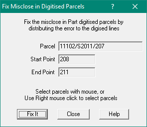
Parcel
Click on a parcel to select it.
Start Point
Click on the start point of the digitised lines in the selected parcel.
The point must be on the main close and be before the end point.
End Point
Click on the end point of the digitised lines.
Click on "Fix It"
You can now check the parcel misclose to see what has been changed.
To include this Tool in Geocadastre, there has to be the following entry in the MenuColumn section of the Config file.
menuEntry menuText="Fix Misclose in Part Digitised Parcels" menuItem="MENU_EXCLUDE_INCLUDED_PARCELS"
The change to the config file can be made using a text editor.